
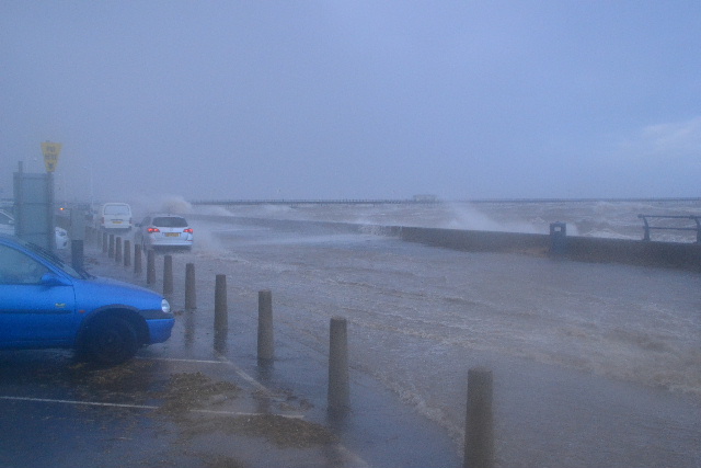
Storm Hector looks set to batter Southport this morning. A high tide at midday with a westerly gale could bring problems for drivers using the Marine Drive.
Further details
A very windy spell will develop during Wednesday night in association with a deep area of low pressure, now named Storm Hector. The strongest winds will reach Northern Ireland during the early hours of Thursday before spreading eastwards across other northern parts of the UK during the morning.
Westerly winds are likely to gust between 50 and 60 mph in many areas and possibly around 70 mph in some exposed locations. Winds should gradually ease from the west during Thursday afternoon. In addition, a spell of heavy rain will accompany the wind with the highest rainfall totals over parts of western Scotland.
Within the warning area, the greatest potential for disruption is likely to be in northern parts of Northern Ireland around rush hour on Thursday and later in the morning across southern and central parts of Scotland.
It is possible that Amber warnings may be issued for some areas later on Wednesday or early on Thursday if this risk increases further.
|
||||||||
|
WANTED: YOUR NEWS AND STORIES FOR SOUTHPORT
Email local news to us including image(s) southport@qlocal.co.uk Follow / Report to us on Twitter @SouthportQlocal Follow / Comment with us on Facebook qlocalsouthport
WANTED: YOUR NEWS AND STORIES FOR SOUTHPORT
Email local news to us including image(s) southport@qlocal.co.uk Follow / Report to us on Twitter @SouthportQlocal Follow / Comment with us on Facebook qlocalsouthport Check Todays Deals on Ebay.co.uk Your Comments:

Custom Search

|
You are in:
UK /
Southport / North West
Find any Town in the UK, or Use UK map Local Google MAP for Southport Check Todays Deals On Amazon.co.uk Check Todays Deals on Ebay.co.uk  Also website at southportnews.co.uk

Qlocal Supports Woodlands Animal Sanctuary 


 Be Seen - Advertise on Qlocal Corporate Sponsors
Southport Piano and Music Academy Washroom Services Maximum Grounds Maintenance Southport Garden Services Ormskirk Garden Services Sanitary Bins Nappy Bins & Waste Disposal Confidential Shredding Services Legionella Risk Testing London Washroom Services Croydon Washroom Services Hounslow Washroom Services Wandsworth Washroom Services Havering Washroom Services Sanitary Bins London Clinical Waste London General Waste London Legionella Testing London Shredding London Tatoo Waste London Preston Bird Control Blackpool Bird Control
UK, Local Online News Community, Forums, Chats, For Sale, Classified, Offers, Vouchers, Events, Motors Sale, Property For Sale Rent, Jobs, Hotels, Taxi, Restaurants, Pubs, Clubs, Pictures, Sports, Charities, Lost Found
southport,
southport News,
|
|||||||

 Reply With Quote
|
|


|
|